Full Wets in the Dangerous Archipelago
This from the RCC Pilotage Foundation, “The Pacific Crossing Guide” (2nd Ed.):
“When clearing out of the Marquesas, the choice has to be made as to whether to visit one or more atolls in the Tuamoto Archipelago, or skirt the north-west corner and head directly for Papeete. The Tuamotus were known as the Dangerous Archipelago, although the advent of GPS and radar have considerably reduced that danger, but not entirely.
“The general acceptance of GPS as a means of position fixing is a huge advance, but it must not be considered the ultimate answer to safe navigation in the Tuamotus. The indicated position on the screen can be extremely accurate in terms of geographical coordinates, but the problems arise when the chart is not to the same accuracy. The available information is very limited in the first place, and all of it is based on surveys carried out long before satellite-derived positions were even dreamed of,so that longitude in particular is sometimes seriously in error. During the hours of darkness, a wide margin of error must be allowed for, with unpredictable streams to be expected. Radar is of some help, but the echoes are difficult to read clearly and the sensible sailor will stand off until daylight whenever there is the least doubt.”
The Tuamotus are beautiful, so we had heard. Beautiful but perilous. Once through the tiny gap in the reef surrounding each atoll, crystal clear waters brim with beautiful fish around perfect coral reefs. Some islands remain uninhabited, the archetypal desert islands with sparkling waters and white sand beaches. Some are still suffering the after-effects of French nuclear testing from the 1960s to 1990s, but we were several hundred miles away from those. Part-dismantled and part-abandoned, the old testing facilities are still there to visit on Moruroa and other islands, but oddly, they don’t see much tourism. We, however, had already decided to go straight to Tahiti from the Marquesas, not least because, with a 9′ draught, getting in and out of any of the Tuamotu atolls could have been very interesting, with or without tidal streams and countercurrents. We also needed some spare parts reasonably urgently. Of course, our anchor windlass then failed in the beautiful bay of Taiohae in Nuku Hiva, so our choice was cemented.
(As an aside, if your fan/drive belt ever breaks somewhere really remote and you discover that the muppets who last serviced your equipment supplied you with spare fan belts in the wrong size, Dietmar can now explain to you in detail how to make a replacement one from a different sized fan belt, using sail repair twine. I am not joking. He is a legend.)
As the crow flies (not many of those round here), Tahiti is nearly 800 miles from Nuku Hiva in the Marquesas. The most direct route however goes straight through the middle of the Tuamotus archipelago, which runs NW to SE and is 1,000 miles long. To go around the NW end, as suggested in every book, would mean an extra 150 miles, or about an extra day of sailing, including the last 100 miles sailing upwind to Tahiti in 3m waves. We umm-ed and we aah-ed. Typically, Dietmar is brave and generally quite optimistic and I am much more cautious and mindful of all the things that could potentially go wrong. This sometimes makes for interesting conversations…
In the end, I conceded that the additional 150 miles needed to go right around the outside of the archipelago was probably unnecessary, plus I didn’t much fancy 100 miles of sailing straight into the forecast 25 knots of wind. We were going to go through the middle.
“Atolls of the Tuamotus were first seen by European eyes in 1615. Jacob LeMaire, a Dutchman, had sailed near the northwestern end in a passage from Cape Horn (which he named) to Batavia, now part of Indonesia. So many other ships have since accidentally and disastrously discovered the archipelago that it is sometimes known as the Dangerous Archipelago. In recent years, many carelessly navigated yachts have added further emphasis to this gloomy name.”
(Landfalls of Paradise. 5th Ed. Cruising Guide to the Pacific Islands)
We dodged a few monster squalls on the passage down towards the island chain but as we neared the archipelago, a serious squall passed over us. For 40 minutes we were pelted with rain and flew along at 8-9kts in over 30kts of wind with just the jib and mizzen. It didn’t feel like a good omen. The weather forecast, whichever one we chose to believe, said we would have at least 20kts in the night as we came between the islands, with squalls. Normally this wouldn’t be all that worrying, but we knew that the tidal flows in and out of the atolls can influence the state of the sea up to 9 miles away and every book we read said that the currents can be…how should I put this…interesting? When you are so close to (effectively) invisible atolls and their surrounding reefs, there is precious little opportunity to run before the wind if it really blows. And there is the possibility of the thing that every sailor dreads – wind against tide. Add that to the fact that the charts could have a 4 mile (!) margin of error here, and you can imagine what was going through my head at least. This was going to be a test for us, that was for sure.
Mindful of the challenge, we adjusted our speed accordingly so that we would go past the first islands (Manihi to our starboard and the Iles du Roi Georges (Takaroa and Takapoto) to port) in daylight, cross the wider stretch of open water between the and then again through the 19 mile wide pass between Arutua and Rangiroa after daybreak.
We could see the palm trees on little Manihi waving guilelessly in the wind to our starboard side as we adjusted our course to sail west to our chosen pass. Hello Manihi. You look pretty. Sorry we can’t stop. Must dash
At this point, the wind began to build, but unhelpfully had shifted to ENE and our course change meant that we were no longer on a comfortable beam reach but the wind was now behind us with the swell on our quarter. To sail this at a sensible speed, we would have to pole out the genoa or put the mainsail back up. Bearing in mind everything we had read, we chose the safer option – start the engine and take the sails down. I had already battened down the hatches several hours before (this is not just a metaphor). As the sun set, a beautiful yellowfin tuna took Dietmar’s lure. About 2′ long and about 4kg, this would be perfect for at least 2 meals. I didn’t feel at all like cooking (or eating, to be honest) so we had sushi with fresh Marquesas-grown limes, pickled ginger and some salad. It was absolutely delicious.
Just as we finished supper, a wave came over the back of the boat and gave our cockpit a good wash. I decided to get my full wets out of the locker. This was going to be an interesting night, I was sure.
Dietmar went to get some sleep, ready for action again at about 3am when we would again be approaching our next waypoint and getting ready to make the turn through the second set of islands. For the first time since the Atlantic, I put on full sailing dungarees and jacket, battened down my own hatches (this time it is a metaphor ;)) and went to sit in the cockpit. I shut the companionway hatch, clipped on tight and tried to make myself comfortable in the corner, huddled beside the tiny spray hood. I had the remote for the chart plotter so I could keep checking our course without having to move, and a book of puzzles in German – the kind that old ladies have on trains. The puzzles are probably pretty easy if you are German. Sometimes for me it feels like deciphering hieroglyphs, but it’s good for my brain, or so I keep telling myself.
Some lights on Manihi, like a siren call to apparent safety within the atoll, glowed on the northern horizon as the wind blew harder and harder, but still from dead behind us.
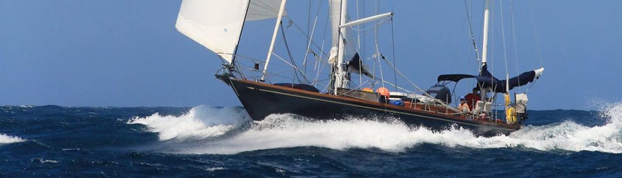
Every so often a wave broke clean over the top of the pushpit and soaked the back of the boat. The waves built and started to come from every direction. Rose (named after my feisty and wonderful Dutch friend Roos), our autopilot, really had to work hard to keep us heading to our waypoint and it was clear that there were some fierce currents at work, doing their best to smash us to bits on a reef somewhere. The wind continued to blow harder. The instruments showed 22 knots. 25 knots. This was just what they call ‘apparent’ wind. We were being pushed along at nearly 9 knots at times – this meant we had nearly 35kts of true wind. Force 8 on the Beaufort Scale, or for my landlubber friends again, Very Bloody Windy. CESARINA rolled violently in the swell and the waves, back and forth and side to side, like a grisly rollercoaster in the pitch black. No stars to be seen. Disney ain’t got nothing on this.
Too much wind to do any more word games. No more distractions. I kept checking the plotter and also the Garmin charts also loaded on the iPad, just to be absolutely sure. The radar clearly showed the reefs. I tried not to imagine how big the breakers must be to show that clearly at 16 miles away.
I woke Dietmar as the battery died on the iPad and I could no longer easily see the plotter. I was still wide awake, fortified by a heady mixture of strong black coffee, Marlboro cigarettes and pure adrenaline. I had no intention of going to bed but my Captain insisted. I said there was no point as there was no way I would be able to sleep. He still insisted. He said I needed my sleep in case things got interesting later. I was adamant that there was no point in getting into bed. As it turned out, I was completely wrong and I fell asleep immediately and slept heavily, albeit with psychedelic dreams, until my alarm went off two hours later.
At 4.30am we started to make our turn towards the south, to go through the pass between Rangiroa and Arutua. Dietmar hoisted the mizzen sail again and unfurled half the genoa. I was keen to let the engine continue to run, just in case we had problems but after about half an hour, conditions seemed fairly stable. CESARINA was now heeling with the wind on her beam again and not rolling around so much. As we came between the islands, the water was much calmer than we had expected, but we were clearly sailing against the current. We watched more pretty palm trees cheerily fluttering in the far distance in the early morning light on the reef of Arutoa and daydreamed of a quiet anchorage and a working anchor winch. Soon, whispered CESARINA. But not today.
Once out of the passage, the seas again rose around us. The swell and the waves were at 90 degrees to each other and the seas were once more very confused. We had up to 20knots on the beam and we were charging through the waves at between 6.5 and nearly 9 knots. CESARINA’s humans were exhausted, but she battled on back out into the open ocean. As Dietmar will tell you, this is exactly the kind of sailing for which she was built. We, on the other hand
As I write, 150 miles later, we have Tahiti in sight. The Pacific Ocean is a glorious, gently rolling field of cobalt blue, stretching as far as the eye can see in every direction, interrupted only by a picture postcard island 25 miles ahead of us. The VHF occasionally squawks in French. The sun is hot, the skies are endlessly blue, all is well. We are once again motorsailing in order to come into Pape’ete Marina in daylight. 752 miles of excitement under our keel, and this time I am delighted to report that we haven’t broken a single egg.
Heart thumping joy or sheet terror!
Sail boats conjure up such romantic images. We dream of chucking in the 9 to 5, heading off into the wild reaches of foreign seas, never again having to answer to anybody apart from the elements that is! And oh my days were you answerable!!. So happy you are both still breathing and were not turned into mermaids/mermen! x
Helle Sailors,
It’s always very interesting to Reader about real situations on the Ocean and the conditions Ehen passing througjh areas which were nöt Seen by so many Sailors.
Your wording is super
Dear Emma, what a report -great ! Like your writing, although a dictionary is needed sometimes.
As sended to Dietmar, I have your actual location (British Admirality Chart) ahead of me – since decades. Have a great time in the Society Islands !
Cheers
Michael, HH.